 Tyson Lake, April 30, 2010. As the lake level was drawn down, ice came to rest on the sediment delta at the left side of the picture causing silt to be distributed throughout the lake. The only visible patch of open water is over the former delta.” Photo D. Bouman
(Click on “read more” to see a larger photo.)
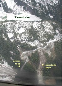
The straight line is the penstock pipe, the wiggly one under snow is the access road. The open water in the lake is on the extreme upper left. A tunnel connects the lake with the penstock pipe. The road is an access to the tunnel and leads to a “spoilage site”, where waste rock from drilling the tunnel was dumped.
